


thanks bro, sorry nagkamali pa ako sa pag post ng thread, nakita ko na ang thread about gps sa car electronicsOriginally Posted by 111prez

The Largest Car Forum in the Philippines
- Forums
- Discussions
- Events
- Community
Results 41 to 60 of 758
Hybrid View
-

 Verified Tsikot Member

- Join Date
- Sep 2005
- Posts
- 128
December 6th, 2005 11:28 AM #1
-
 Verified Tsikot Member
- Join Date
- Mar 2007
- Posts
- 33
May 22nd, 2007 11:49 PM #2
http://philgpsusers.blogspot.com/200...g-ortigas.html
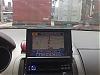
Just took a picture of my GPS console while driving along Ortigas Avenue. This is intended to be launched in 6 months time and aimed to be priced almost half that of n95. It has a large screen with touchscreen interface and MP3 player. It has voice and routing capability.
- duke9631
-
 Tsikot Member Rank 3
- Join Date
- Jul 2006
- Posts
- 713
May 23rd, 2007 07:39 AM #3pioneer also offers GPS system thru their 2006 product called Vehicle Dynamic Processor. It can be interfaced with 2006 pioneer's selected products 2-DIN and in-dash LCD monitor HU. It is proced at 30,000 php. Also this processor can monitor your horsepower, torque, angle, elevation, acceleration ,speed, etc with different kinds of modes..
-
Verified Tsikot Member
- Join Date
- Sep 2005
- Posts
- 128
December 6th, 2005 10:26 AM #4mga peeps, may nag-iinstall na ba ng gps navigation sa mga sasakyan dito sa pinas? meron na ba tayong existing provider? sa palagay ko maganda kasi malaki ang tulong nya in finding places. di mo na kailangang bulaklatin ang road map mo. standard feature na kasi yan sa tate at europe.
-
 BANNED BANNED BANNED
- Join Date
- Feb 2003
- Posts
- 136
December 7th, 2005 01:38 PM #5So far wala pre. What we have now here in Phils are GIS cos who happens to have digital maps ng Pinas which they use as part of their business by subscribing to these cos to track or locate your car and not to give a service of finding a certain location. Isa pa, mahirap maglaunch ng ganyang service dito sa tin kasi pabago-bago ang daan like names of the street, and the right direction kasi minsan two-way then minsan one-way.
-
Verified Tsikot Member
- Join Date
- Apr 2005
- Posts
- 40
December 7th, 2005 01:46 PM #6*cesar actualy bro meron na dito sa pinas ngayon..you just need to buy a device like mitac and it is buddle with guideme software developed by a local company which also the developer of findme vps and trackme. alam ko a-toyz nagbebenta ng mitac
guideme software can locate your location and plot it on the map. to know about the software just visit www.findme.com.ph
-
BANNED BANNED BANNED
- Join Date
- Feb 2003
- Posts
- 136
December 7th, 2005 01:56 PM #7Wala bang subscription ito? Just what i said Findme is a GIS company that sells their services on location base system. So if this Mitac that u said is a device u can install sa sasakyan mo, who will update the data on it?
-
Verified Tsikot Member
- Join Date
- Apr 2005
- Posts
- 40
December 8th, 2005 10:51 AM #8Findme is a GIS company that sells their services but also their the one who developed the GuideMe software. yup i know may subcription ito for the use of their map kasi every year may nagbabago sa map and para updated naman map mo..for the first year alam ko free yung subcription. I used to work before sa findme as a developer. Originally Posted by cesar

-
 Tsikot Member Rank 3
- Join Date
- Oct 2005
- Posts
- 780
December 8th, 2005 12:58 AM #9Mga tsikoteers, i know ang pinaguusapan ay GPS sa Pinas, pero gusto ko lang pong i share ang experience ko sa aking GPS device, gaya po ng sinabi ni vindiesel they're readily available sa europe, us at lalo na po sa japan. pero hindi kailangan ng installer, you can get a portable one kagaya po ng sa akin, at hindi rin po kailangan mag subscribe cause its free. These are very reliable little devices, para pong may navigator ka sa passenger side, every time po na lalarga kami sa malalayong lugar ay naka gps, at may voice guide pa kahit hindi ka na tingin ng tingin sa gps, all you have to do is listen at kung na-miss mo exit or turn ay usually re-route ka ng gps automatically. Ni minsan eh di po kami naligaw. Ang set up ko po ay PDA, portable GPS (nakalagay sa CF slot ng PDA) at Mapping software (Destinator 3 map of western Europe). Kung po sa Pinas ay readily available mga PDA at GPS naman u can get online pero po ang mapping software hindi po ako sure kung meron o available na.
-
Verified Tsikot Member
- Join Date
- Jun 2004
- Posts
- 252
-
Tsikot Member Rank 3
- Join Date
- Oct 2005
- Posts
- 780
December 8th, 2005 02:32 AM #11brito, i think mga $200 back then...here is the site...
yung SysOn na 2 in 1
http://www.buygpsnow.com/category.aspx?categoryID=10
-
 Tsikot Member Rank 3
- Join Date
- Sep 2005
- Posts
- 1,218
December 8th, 2005 02:58 AM #12Here's the thread regarding the Mitac PDA SatNav ... http://tsikot.yehey.com/forums/showt...ighlight=mitac . Unfortunately I didn't get the answer as to why there's a subscription fee, though I assume it's for the vehicle tracking function (as opposed to navigating).
-
 Tsikot Member Rank 3
- Join Date
- Feb 2005
- Posts
- 857
December 8th, 2005 08:55 AM #13I have a Garmin GPSMAP60 which I use for out of town trips. You can download maps kaya lang general map lang for pinas. Medyo out of sync pa sa actual. Is there a way for me to create my own map and upload to my GPS?
-
 Bad Blood
- Join Date
- Jul 2005
- Posts
- 327
December 13th, 2005 10:33 AM #14bakit di na lang they sell na lang yung updated version para wala ng fee, like sa mga yachts. yung Garmin ng US na kinabit namin sa fishing boat binilhan namin ng mapping/chart ng philippines (mas mahal pa dun sa unit) pero walang subscription. Sana ganun na lang, pero, teka nga pala bro, why need a gps since philippines is a small country? Yung bang mga BMw's na binebenta dito na may sharks fin may GPS like sa abroad?
-
Tsikot Member Rank 3
- Join Date
- Sep 2005
- Posts
- 1,218
December 14th, 2005 02:15 AM #15They want to earn more money Originally Posted by RedHotBlood
... first, by selling the software and second, through updates. Fair enough, since Philippine roads always change (through addition, direction or change of name).
Regarding BMW shark fins ... it is a part that signifies the car is BlueTooth prepared, not necessarily meaning it also has SatNav/GPS (the GPS and phone antennas are both in the fin).
For everybody's info ... before May 2000, civilian GPS receivers have Selective Availability, which is an intentional degradation in accuracy to prevent hostile acts against the USA using their own techonolgy (the GPS system). Typical accuracy is between 20-50 meters. After 2000, Selective Availability has been eliminated, but the US Department of Defense now has the technology to localize the control system to deny GPS signals to selected areas in order to protect them. Typical accuracy for a civilian receiver is now within 10-20 meters.
*cesar, masyado namang nakakaiyak yung 1km-10km error ... even my cheap Navman can accurately tell my position within 20 feet. Today's entry-level SatNav systems from Garmin, Navman and TomTom will guide you literally from door-to-door addresses.
-
Tsikot Member Rank 3
- Join Date
- Feb 2005
- Posts
- 857
December 13th, 2005 10:52 AM #16There are a lot of uses for the gps other than giving you directions. Even if Pinas is such a small country, there are places that you go to which you are not familiar. This way if you get lost, you can back track. I also use it in gauging the shortest route to a place that I usually go to. I usually go to Anilao and there are several ways to go there. Having a GPS helps me determine the shortest route. Of course the shortest does not necessarily mean the fastest. I also use it in mapping off shore sites. I do a lot of diving and there are sites that are hard to find specially if your triangulates do not appear well due to weather conditions. Finally, I always like to know my general location when I go out of town. It helps me keep my bearings.
-
Verified Tsikot Member
- Join Date
- Mar 2005
- Posts
- 33
December 13th, 2005 06:08 PM #17Anong GPS ang gamit mo ang where did you get the map? Is it detailed (includes minor streets)? Originally Posted by zeagle
-
Tsikot Member Rank 3
- Join Date
- Feb 2005
- Posts
- 857
December 14th, 2005 12:06 AM #18Garmin GPSMAP60. Just a general map with just major highway like EDSA and South Superhighway. It comes with the GPS. Originally Posted by knightblade
-
BANNED BANNED BANNED
- Join Date
- Feb 2003
- Posts
- 136
December 13th, 2005 01:06 PM #19Also, kapag ginawa nila yung walang subscription di nawalan sila ng business! Like i said GIS co here in Phils have their own mapping software. Ung iba nga di gaanong accurate off ng mga 1km to 10km. That's why they keep on updating their system.
Actually, kung matyaga ka u can do ur own map using GPS device like Garmin etc. By doing this mas accurate ung map mo kasi GPS generated ung map hindi ung galing sa mapa and iniscan then they plot the coordinates dun sa map.
-
Verified Tsikot Member
- Join Date
- Mar 2005
- Posts
- 33
December 13th, 2005 06:01 PM #20Nung umuwi ako ng Pinas (a year ago), I used my Garmin Ique 3600 (PDA/GPS). Kaso walang akong detailed map ng Philippines so yung world-map lang ang gamit ko which show major highways only. Meron ba kayong alam na contact details ng Guideme? Para matanong ko kung yung software nila is compatible with my unit.


 Reply With Quote